
Map areas
An area claims part of a map: a kingdom, a district, a forest, a room. Linked to a location, it is that place on this map, and its own map is the next level down. Unlinked, it just marks something (a mountain range, a weather zone, a faction's land) with no file. An unlinked area can also be an exit, such as a road out or a cave mouth (see exits). An area is a place or a way, never both. Neighbouring areas can share a border exactly: give them the same corners where they meet.
To add or change one, use the Area tool: Polygon (P), Rectangle (U), Circle (C) or Hexagon (X).
Corners snap to nearby shapes as you draw. Craft asks which location to link when you finish drawing. An unlinked area has Create Nested Area Map, which makes a detailed map of that part of the picture and links it.
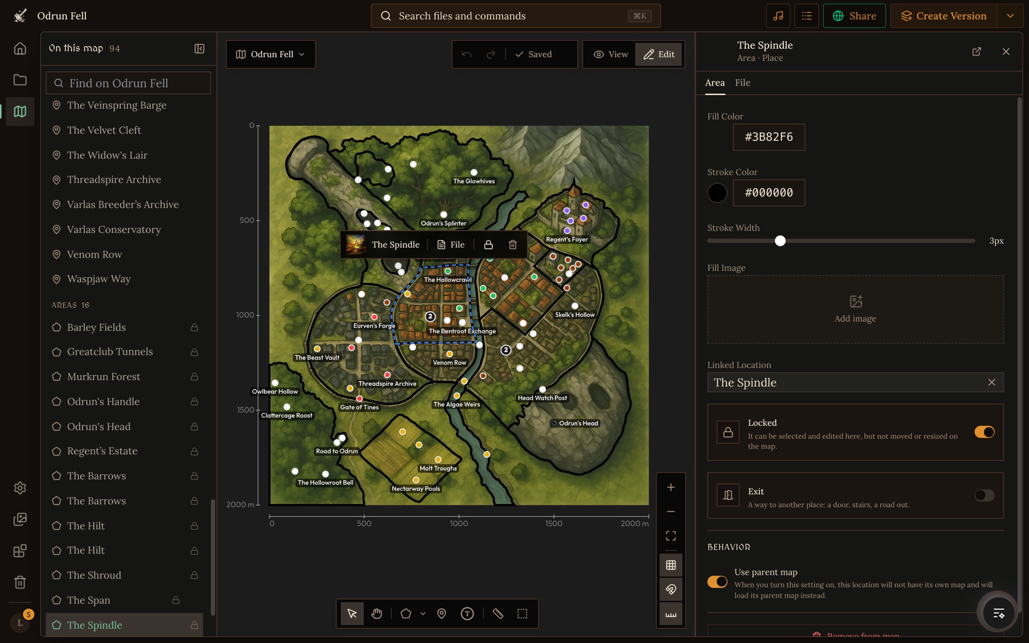
Area fields
id
The area's own id, unique on this map.
| Field | Type | Required | Default | What it is |
|---|---|---|---|---|
id |
string |
yes |
label
The name shown on the map. Left out, the linked file's name is shown.
| Field | Type | Required | Default | What it is |
|---|---|---|---|---|
label |
string |
Name it as players will say it.
fileReferenceId
The location it outlines, by reference id. Null for a shape with no file.
| Field | Type | Required | Default | What it is |
|---|---|---|---|---|
fileReferenceId |
string | null |
Link the location the area is. Leave it null for a shape that is only a mark.
vertices
The outline's corners in order, at least three.
| Field | Type | Required | Default | What it is |
|---|---|---|---|---|
vertices |
({ x, y })[] |
yes | ||
vertices.x |
number |
yes | Across the map: 0 at the left edge, 1 at the right. | |
vertices.y |
number |
yes | Down the map: 0 at the top edge, 1 at the bottom. |
List the corners in order around the outline. Put them where the place is in the map's picture.
{ "vertices": [{ "x": 0.55, "y": 0.2 }, { "x": 0.9, "y": 0.25 }, { "x": 0.8, "y": 0.6 }] }
style
How the outline is drawn.
| Field | Type | Required | Default | What it is |
|---|---|---|---|---|
style |
{ fillColor, fillOpacity?, strokeColor, strokeWidth } |
yes | ||
style.fillColor |
string |
yes | The fill's color. | |
style.fillOpacity |
number |
0.2 |
How strongly the fill shows, 0 to 1. | |
style.strokeColor |
string |
yes | The outline's color. | |
style.strokeWidth |
number |
yes | The outline's width. |
{ "style": { "fillColor": "#b45309", "fillOpacity": 0.2, "strokeColor": "#b45309", "strokeWidth": 2 } }
fillImage
A picture inside the outline (a forest texture, a banner), or null.
| Field | Type | Required | Default | What it is |
|---|---|---|---|---|
fillImage |
{ url, offset, scale, opacity? } | null |
|||
fillImage.url |
string |
yes | The picture's URL: an uploaded or generated image. | |
fillImage.offset |
{ x, y } |
yes | Moves the picture inside the outline. | |
fillImage.scale |
number |
yes | The picture's size. | |
fillImage.opacity |
number |
1 |
How strongly the picture shows, 0 to 1. |
To set it, use Fill Image in the area's panel. A texture turns a flat region into forest, dunes or a faction's colours.
locked
Locked in place, so it can't be dragged or removed by mistake.
| Field | Type | Required | Default | What it is |
|---|---|---|---|---|
locked |
boolean |
To set it, use the lock on the element's selection bar, or Lock element in its right-click menu.
exit
Makes it an exit, a way to another place: a door, stairs, a road out.
| Field | Type | Required | Default | What it is |
|---|---|---|---|---|
exit |
object |
To set it, use the Exit switch in the pin's or area's panel. Its fields are in exits.