
Maps
A map belongs to a location: any file whose type has the location designation can carry one. A world map holds its regions, a region its towns, a town its taverns, and each place's own map is the next level down. Maps are where play happens. The GM keeps every scene on one: who stands where, which ways lead out, how far the next place is. So a map is built to be played on, not only looked at.
How it is used
- Maps are made of locations. You write a place as a location file, then draw it on another place's map as an area or a pin linked to that file. Its own map is the next level down. The map is stored with the location file, so copies, versions, packages and games carry it.
- The root map is the top. It opens first in the Maps view, players start from it when they open the world map in a game, and visitors can pan it on the world's page. Choose it in the Maps view, or under Root map in the current root map's Map settings.
- The scale is how the GM measures. A map's scale (its real width) gives distances, travel times, whether one place sits inside another, and whether a map is ground for a scene (a room, a camp) or country you travel across (a region, a kingdom). A map wider than about 300 m that holds other places is country: moving across it is a journey.
- A square grid makes scenes play in squares. On a place's own map with a square grid and a scale, the GM knows each person's square, who is within reach, and moves people square by square. Hex grids aren't played in squares, and neither is a place shown on its parent's map.
- Tokens say where characters are. Character files have no location field. A character's token on a place's map puts them there: they are brought into a game start's opening scene when that place is chosen as its starting location, join the scene when the party arrives, and are found there when the story looks for them. Several tokens of one creature file become numbered copies.
- Terrain and walls say where people can stand. On a battle map, impassable ground at the scene's edges (the sea around an island, a cliff, the rock around a cave), the map's own kinds of ground (water, lava) and walls tell the GM where nobody can stand and what stops them. It walks every move around them and is told how far the walk really was and what ground it crossed (terrain and walls).
- Exits are the ways between places. A pin or area that is an exit (a door, stairs, a gate, a road out) tells the GM how to get from this map to another place, and where the party comes in on the other side. The GM follows exits, and linked locations, when the party moves.
- A pin or area is a place or a way, never both. Linked to a location, it is that place on this map: the tavern's pin on the town's map shows where the tavern is, and going into it moves the scene to the tavern. It needs no exit. An exit links nothing: inside the tavern, the front door is an exit back out to the town, and the staircase is an exit up to the second floor's location. So the town's map has the tavern's pin, and the tavern's own map has its doors and stairs.
- The GM reads the picture. When a map gets its picture, Craft notes the features drawn in it (the bar, the windows, the gate) and where each is, so the GM can put someone "by the window" without a pin there. Your own areas and pins always win over what it saw. Reading the map shows the same features.
- Which map holds a place. A place's parent is the place it is linked as inside, if any. Otherwise it is the most detailed map that draws it: a tavern pinned on the city map and on its district's map belongs to the district. When two maps draw it and neither holds the other, a parent field on the location (such as "Parent Location") settles it. A place set to use its parent's map has no map of its own, and its scenes play on that map.
- Players see the scene's map. In a game they can drag people on it, go up to the world map, pick a place and travel there. They see markers on the map's exits, except hidden ones, so a secret door stays secret.
- The GM makes places too. When the story goes somewhere the world doesn't have, the GM makes the place in that game, with a picture and a map at a fitting scale: a battle map for a room or a camp, a town plan for a village, a regional map for wild country. A part of an existing place (a cellar under the kitchens) is linked to it as a linked location, not pinned. These places live in that game only.
Scene maps and travel maps
A world needs two kinds of map, and the GM uses them differently. To build either, follow building a map.
- A scene map is a place small enough to play a scene on: a room, a tavern, a camp, a street. People stand on it as tokens. It usually has a square grid.
- A travel map shows places and the ways between them: a region, a kingdom, the world. The party crosses it as a journey.
A world's maps make a tree, like a graph of its places. The root travel map is at the top (the region, the kingdom), the places on it below, and each of those leads down to the scene maps where play happens. Interiors are scene maps: the inn's common room, the storehouse, the hut, the cave. A place in between, such as a village, an island or a castle yard, is both at once: scenes play on its ground, and the buildings drawn on it lead down to their own maps. Going into a place drawn on a map moves the scene to that place's own map, and stepping out comes back up.
Craft tells them apart by size. As a rule of thumb, a map with a grid is a scene map up to about 3 km across, and a map with no grid is a scene map up to about 500 m across. Anything wider is a travel map. A map with no scale can only be guessed at, which is one more reason to set one.
What good maps have:
- The world has a root map.
- Scene maps lead somewhere. This matters most. Every scene map has exits or linked locations, so the party can leave and the GM knows where they come out. A scene map with no way out is a dead end.
- There are enough scene maps. If the only maps are of cities and regions, every scene plays out on a map built for travel, crowded with things that have nothing to do with the scene. Give the places where play happens their own small maps.
- Scene maps are simple. About six character tokens or fewer, and only the areas and pins the scene uses. Marking the spots that matter helps the GM put people in the right place; marking everything doesn't.
- Big maps aren't overloaded. A map with more than about 50 things on it is hard for the GM to use. On a scene map, split it into smaller maps. On a world or regional map, splitting it by region is worth doing but not necessary.
Making and changing a map
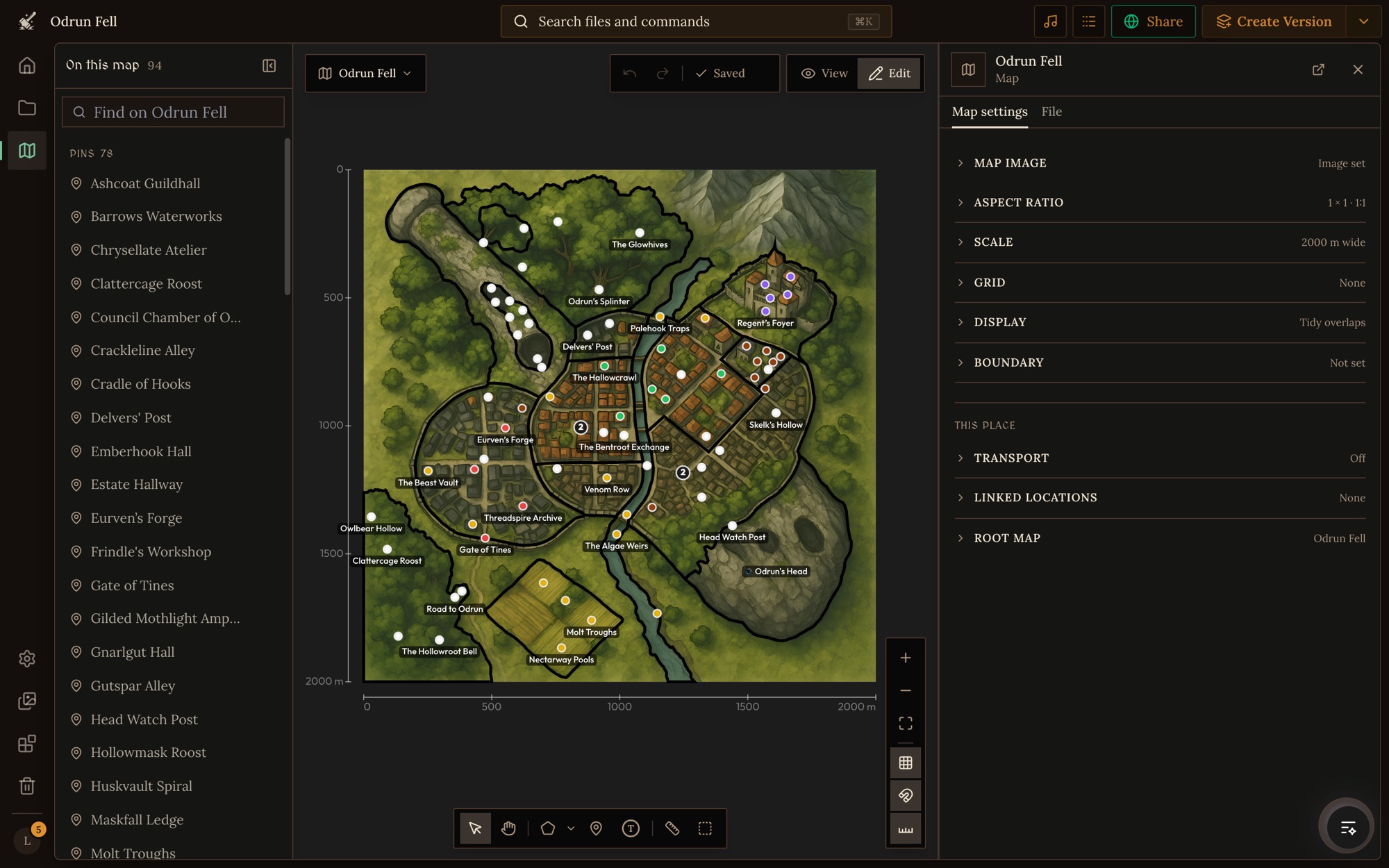
A map is read and changed with the map editor: Maps in the workspace's left rail, or View on map on a location. Each part has its own reference below.
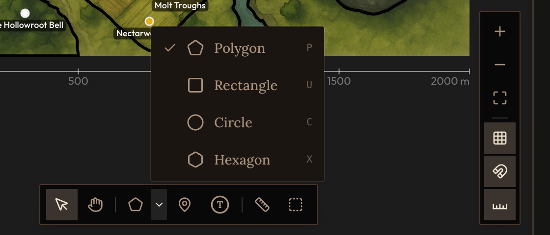
The map editor has the canvas in the middle with the toolbar under it, On this map on the left (everything drawn on this map, and Not on this map yet for places that belong here but have no pin), and the side panel on the right: the selected element's settings, or Map settings when nothing is selected. It saves a moment after each change. View shows the map as players see it.
The place graph shows how all of a world's places connect: what is inside what, and the exits and routes between them. It finds a route between two places and warns about places a player can't reach or can't get back from. Open it with How places connect in the map editor.
A map's look
A map's picture is generated like any other picture in the world (style instructions), so its look is set in a few places:
- The art direction. Every generated map takes the world's art direction. The location type's own style is left out of maps: it frames the type's cover pictures ("a wide view of the place"), which would pull a map out of top-down.
- The map background reference image. A location type can hold a picture whose art style generated maps of that type copy: the map a new place gets on its own, the map editor's Generate, and the maps the GM draws in play. It is used for maps only, so a look meant for maps goes here. It is in the file type's settings, under Reference image (and Map background reference image for a location type), and only image models with an edit mode can use it.
- One map's prompt. What you ask for when you generate a map applies to that map alone. The map editor's generate dialog also shows the style text, and changing it there changes only that picture.
- The GM frames its maps by scale. A place the size of a scene gets a battle map: a floor plan with the roof off, or the ground of one spot. A village, a town or wild country gets a town plan or a regional map. Both are seen from directly above, never in perspective. When the type has no map reference image, the GM copies the look of a similar place's map in the world.
- There is no style preset. Nothing switches every map to a new look. Changing the art direction, the type's style or its reference image changes only maps made after it, so regenerate each map you want restyled. Its areas and pins stay where they were: check them against the new picture.
- The grid and overlays are the map's own. The grid's line color and how strongly it shows, and images laid over the picture, are in the map's settings (background and grid).
Doing it well
- Pins agree with the ways between them. When places on a map are also linked by a way with a time or distance (a sea lane of 3 days), place the pins where the places were described, then measure each way on the map and note which ones disagree with the scale, rather than working out a layout that fits them all. Two travel times that disagree confuse the GM.
- Set a real scale on every map. "75 ft" for a hall, "2000 m" for a city, "300 mi" for a kingdom. A map with no scale leaves the GM guessing. A scale of exactly 1 mile was the old default, so the GM trusts it less: where the place is also outlined on its parent's map, it takes the place's size from that outline. For a map really a mile across, enter 5280 ft (1.6 km in a world measured in metres).
- Grids where fights happen. Rooms, lairs, camps, a ship's deck. A region or world map needs a scale, not a grid.
- Build only the levels you need. A one-shot can live on one tavern map; a campaign can stop at its cities. Give anywhere people will fight, sneak or explore room by room its own map. Let a waystone or a market stall use its parent's map.
- Draw the picture to fit the places. The picture is most of a map's quality. Ask for a map, not a scene: "hand-drawn region map, top-down, inked coastlines, parchment". Say where the four to seven places that matter sit ("walled town lower left, river crossing in the middle"), then put their pins where you asked for them and check each against the picture.
- Battle maps are one floor plan. Ask for one connected top-down floor plan at one scale, with rooms joined by corridors. Without it you get a collage of rooms that can't be walked.
- Buildings are places. A building drawn on a map that the party can enter is a nested location: an area over it, linked to its own location file, with its inside as its own scene map.
- Name things as players say them. "The Throne Dais", not "Area 3". Draw the spots the story depends on even when the picture shows them.
- Put a token where each important character lives or works, linked to the character's file.
- Every place that matters is reachable. It is drawn on some map, or linked to one, with exits or linked locations for the ways the story uses. Pair the two sides of each door so arriving parties come in at the right spot.
- Match the aspect ratio to the picture, or pins drift off what they mark.
Mistakes
- No scale, or the old 1 mile default. Distances, travel times and what is inside what come out wrong.
- A grid on a map with no scale. Nothing is played in squares.
- A pin and an exit for the same place. A place reached through an exit (the inn's upper floor) is not drawn on this map as well. The exit is the way there.
- A pin that is a place and an exit. A pin linked to the tavern that is also a door is refused: the pin shows where the tavern is, and the door is its own pin on the tavern's map.
- One-sided doors. An exit with nowhere to come out leaves the game to guess where the party arrives, and going back may come out somewhere else.
- A pin labelled for where it leads. The far side of a door is named for where it sits ("South Door"), not for the place behind it.
- Characters with no token. Nobody knows where they are, so they don't show up when the party arrives.
- A battle map that is all open ground. With no impassable ground or walls, the GM can stand someone in the sea or walk them through a wall the picture shows.
- Buildings left as part of the picture. When the story goes into the inn and the inn is no place of its own, the GM has nowhere to put the scene.
- Pins that miss their art. A pin for the harbour sitting in the mountains reads as broken.
- Hand-written ids that don't match. An exit's
to,arriveAtor an element's file link that names nothing leads nowhere.
Reference
- Map settings: A map's own settings, from its picture, shape and scale to its grid and overlay pictures.
- Map exits: The fields of an exit, a pin or area that is a way to another place, and how to make both sides one door.
- Map pins: The fields of a pin, a marker for a place too small to outline, linked to its location or used as an exit.
- Map areas: The fields of an area, a drawn outline that marks a region, district or room, links it to a location, or makes it an exit.
- Terrain and walls: Where people can't stand on a battle map and what the ground does to them, the walls that stop them, and how the GM walks every move around both.
- Map tokens: The fields of a token, a character or creature on a place's map, and the footprints that set its size.
See also linked locations for places linked with no spot on a map, and game starts for where a game opens.